


Driven by the changes introduced by OS MasterMap for base mapping, Thames Water needed to ensure that all their GIS based systems were able to work seamlessly with the new positional reference data. This prompted a review of GIS across the estate to adopt modern approaches to data management and systems integration in order to improve the performance of the operational, engineering and asset management functions of the organisation. The project had the following objectives:
- Improve data confidence/quality
- Provide an enterprise perspective
- Support asset investment and strategy objectives
- Support goal to become a UK leader in asset planning and regulator management
- Adopt MasterMap for positional reference
- Reduce GIS cost of ownership
Thames Water sought to rationalise the complex mix of geospatial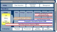 technologies and applications, which had evolved over time, to provide an integrated asset repository that would present a single source of truth. The solution involved the creation of an asset information model to present an holistic picture of the state and history of each asset in the water distribution and treatment networks. The repository is an enterprise resource accessible through industry standard query and data exchange protocols and supports multiple GIS platforms including ESRI, Autodesk and Oracle.