


GIS in Kansas City, Missouri, had developed within each department as the technology evolved to meet specific departmental needs. Over time two major GIS platforms (Integraph GeoMedia and ESRI ArcGIS) emerged as the preferred technologies but exchange of data between them was very problematic and data interoperability was simply not an option. This inability to share data on infrastructure and services between departments in a timely manner lead to a number of problems - such as emergency dispatch centres not being able to determine if a fire hydrant was actually supplied by the water network.
The City appointed a GIS Officer within the CTO's department to 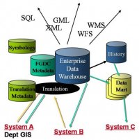 coordinate the development of spatial data quality requirements and supporting standards. This necessiated an enterprise approach to data governance with responsibilities shared between city departments. The city thoroughly investigated the use of Oracle Spatial as a standard database format which could be accessed by either GIS platform. Departments would be able to maintain GIS data using their preferred GIS within a local Oracle database and data could then be published to a common Oracle Spatial hub/warehouse via customised Oracle Streams replication. The approach identified the degree of interoperability that could be achieved as well as the compromises to native GIS functioanlity that would be required. The Oracle toolsets also enabled some tasks to be facilitated though event-driven automated workflow, e.g. positional dependencies between spatial datasets could be established so that if a feature changed in one dataset - potential conflicts in related datasets could be identified and presented as tasks for review and correction.