


The State government of North Dakota in the northern United States comprises a large area that is administered by a number of state government departments. The area is of interest for a number of reasons, some relating national defense issues. A large part of the area is also prone to flooding around Devil's Lake and management of this risk would involve the coordindation of data from FEMA and from multiple departments; a solution was needed very quickly.
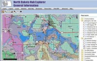 The government of North Dakota appointed a GIS Officer responisble for coorindinating the collection and dissemination for GIS data. Working government departments, a spatial data sharing infrastructure was developed based upon ESRI's emerging 'geography network' concept and tools. The architecture took advantage of the metadata facilities within the ArcGIS and ArcSDE product set which can be registered and accessed externally via the geography network directories. Internally the state used the FME SpatialDirect suite to provide server based spatial data extraction, translation and download. The solution was deployed on IBM WebSphere application servers and internal and external deployments being strictly separated as per state security policy