Delivering Positional Advantage


Case studies
Case studies provide real world examples of where Spatial Consultants staff have applied GIS based technologies and practices to solve business challenges.
Client - City of Kansas City, Missouri
The Challenge:
GIS in Kansas City, Missouri, had developed within each department as the technology evolved to meet specific departmental needs. Over time two major GIS platforms (Integraph GeoMedia and ESRI ArcGIS) emerged as the preferred technologies but exchange of data between them was very problematic and data interoperability was simply not an option. This inability to share data on infrastructure and services between departments in a timely manner lead to a number of problems - such as emergency dispatch centres not being able to determine if a fire hydrant was actually supplied by the water network.
Solution Overview:
The City appointed a GIS Officer within the CTO's department to 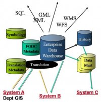 coordinate the development of spatial data quality requirements and supporting standards. This necessiated an enterprise approach to data governance with responsibilities shared between city departments. The city thoroughly investigated the use of Oracle Spatial as a standard database format which could be accessed by either GIS platform. Departments would be able to maintain GIS data using their preferred GIS within a local Oracle database and data could then be published to a common Oracle Spatial hub/warehouse via customised Oracle Streams replication. The approach identified the degree of interoperability that could be achieved as well as the compromises to native GIS functioanlity that would be required. The Oracle toolsets also enabled some tasks to be facilitated though event-driven automated workflow, e.g. positional dependencies between spatial datasets could be established so that if a feature changed in one dataset - potential conflicts in related datasets could be identified and presented as tasks for review and correction.
Client - State of North Dakota
The Challenge:
The State government of North Dakota in the northern United States comprises a large area that is administered by a number of state government departments. The area is of interest for a number of reasons, some relating national defense issues. A large part of the area is also prone to flooding around Devil's Lake and management of this risk would involve the coordindation of data from FEMA and from multiple departments; a solution was needed very quickly.
Solution Overview:
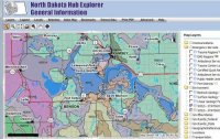 The government of North Dakota appointed a GIS Officer responisble for coorindinating the collection and dissemination for GIS data. Working government departments, a spatial data sharing infrastructure was developed based upon ESRI's emerging 'geography network' concept and tools. The architecture took advantage of the metadata facilities within the ArcGIS and ArcSDE product set which can be registered and accessed externally via the geography network directories. Internally the state used the FME SpatialDirect suite to provide server based spatial data extraction, translation and download. The solution was deployed on IBM WebSphere application servers and internal and external deployments being strictly separated as per state security policy
Client - City of Portland, Oregon
The Challenge:
The GIS Hub project had demonstrated the benefits of a united approach to spatial data management within the City of Portland, USA. Maintaining spatial data to a quality that would support a broader range of uses, however, required significant improvements to the data maintenace and access infrastructure:
- Data integrity rules needed to be automated to improve consistency and efficiency;
- Maintenance costs needed to be reduced;
- Data needed to be accessed by multiple channels including web and potentially mobile;
- Data currency needed to be improved so the updates were made available quickly;
- Data auditing and security controls needed to be strengthened.
Solution Overview:
The EGH (Enterprise GIS Hub) project built upon the progress made by the 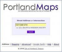 GIS Hub to consolidate all the City disparate GIS systems and data, referred to as the “rich mix of technology”, into a single shared Enterprise GIS data warehouse for all GIS related data in the City of Portland. The project then went further to develop the “Core” rule based GIS data maintenance tools using ArcGIS to maintain the City’s GIS layers while enforcing data quality standards of the Enterprise data models. The maintenance environments of each bureau were integrated with the Hub such that individual data changes were replicated directly to the Hub as they were approved. Finally, a centralized Web infrastructure was developed by CGIS to provide GIS web services to Citizens, Customers and City staff.